

easyAIS

Descripción de easyAIS
“easyAIS” is a free AIS real-time vessel positioning tool designed for the use on AIS receivers with WiFi connectifity.
The Automatic Identification System (AIS) is a maritime transponder/receiver system defined by the IMO (International Maritime Organisation).
AIS main objectives are to improve maritime safety and to protect the maritime environment.
Practically, AIS
•assists collision avoidance (AIS ship-to-ship)
•enables ports and coastal states to identify ships and to manage and supervise the traffic in their waters (AIS Coast station, VTS)
•helps to resolve the difficulty of identifying ships when not in sight (e.g. at night, in radar blind arcs or shadows or at distance)
By means of special VHF transceiver cruise data will be exchanged in short terms automatically. The treatment has a worldwide standard and runs every where. So vessels who use AIS devices from different companies will „see“ each other.
AIS enables to view over obstacles and complements radar. Acording to the antenna instalation hight an AIS station has got a transmission range about 20 to 30 nautical miles.
With the “easyAIS” app by the Weatherdock AG, all AIS targets within range are displayed relative to the user's position.
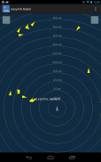
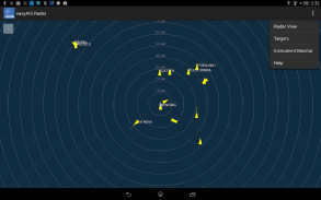
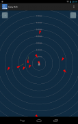
Main screen after starting the app is a virtual radar screen showing the AIS targets in relative position to you
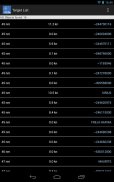
Just tapping the screen on an AIS target brings you to a list with all transmitted details of this target, e.g. GPS position, corse over ground, speed over ground, ship name, call sign, length, width, draft, port of registration …
“easyAIS” works by getting AIS data via WiFi from the AIS receiver or transceiver aboard. Without a running AIS
Notice:
“easyAIS” should not be used for navigational purposes!"EasyAIS" es un AIS en tiempo real gratuita herramienta de posicionamiento buque diseñado para el uso en receptores AIS con connectifity WiFi.
El Sistema de Identificación Automática (AIS) es un transpondedor marítimo / receptor de sistema definido por la OMI (Organización Marítima Internacional).
AIS principales objetivos son mejorar la seguridad marítima y la protección del medio ambiente marítimo.
Prácticamente, AIS
• ayuda a evitar colisiones (AIS de buque a buque)
• permite a los puertos y los estados costeros para identificar los buques y para administrar y supervisar el tráfico en sus aguas (AIS estación costera, VTS)
• ayuda a resolver la dificultad de identificar a los buques cuando no a la vista (por ejemplo, por la noche, en los arcos ciegos de radar o las sombras oa distancia)
Por medio de datos especiales transceptor VHF de crucero serán intercambiados en el corto automáticamente. El tratamiento tiene un estándar en todo el mundo y funciona en todas partes. Así que los buques que utilizan los dispositivos AIS de diferentes empresas "ver" entre sí.
AIS permite ver los obstáculos y complementa radar. Según la altura de instalación de antena de una estación AIS tiene un alcance de transmisión de aproximadamente 20 a 30 millas náuticas.
Con el "easyAIS" de la aplicación de la AG WeatherDock, todos los blancos AIS dentro del rango se muestran con relación a la posición del usuario.
Pantalla principal después de comenzar la aplicación es una pantalla de radar virtual que muestra los blancos AIS en la posición relativa que le
Simplemente tocando la pantalla en un objetivo AIS te lleva a una lista con todos los datos transmitidos de este objetivo, por ejemplo, Posición GPS, corse sobre el fondo, velocidad sobre el nombre del buque suelo, distintivo de llamada, la longitud, anchura, calado, puerto de registro ...
"EasyAIS" trabaja por conseguir los datos AIS a través de WiFi desde el receptor o transceptor AIS a bordo. Sin AIS funcionando
Aviso:
"EasyAIS" no se debe utilizar para fines de navegación!


